
How Do We Measure Plate Movement
- Earthquakes, volcanoes, and mountain ridges are all proof of plate movement.
- The theory of plate tectonics shows that convection currents inside the Earth can affect the crust differently in different places.
- How do scientists measure the distance that plates move?
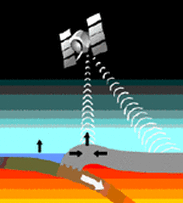
- Scientists use GPS satellites and laser technology to measure the plates movements down to the centimeter.
- Laser pulses are shot from the ground to a satellite to determine the exact location of the plates.
- Research proves that parts of the crust are moving from 1 cm to 12 cm each year.
- The Atlantic Ocean is expanding.
- North America and Europe are being carried away about 3 cm farther apart each year.
- Hawaii is moving closer to Japan at about 8.3 cm each year.
- The theory of plate tectonics shows that convection currents inside the Earth can affect the crust differently in different places.
- How do scientists measure the distance that plates move?
- Scientists use GPS satellites and laser technology to measure the plates movements down to the centimeter.
- Laser pulses are shot from the ground to a satellite to determine the exact location of the plates.
- Research proves that parts of the crust are moving from 1 cm to 12 cm each year.
- The Atlantic Ocean is expanding.
- North America and Europe are being carried away about 3 cm farther apart each year.
- Hawaii is moving closer to Japan at about 8.3 cm each year.

